
City of Salem Adds Historic Road Paving Data to Online Map
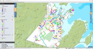
As the City of Salem works to add even more open source data into its online geographic information system (GIS) and mapping tools, at www.mapsonline.net/salemma, today Mayor Driscoll announced that the City has posted information on 201 street paving projects that took place from 2008 through 2015.
“Through the state’s Chapter 90 funding and our own local funding, the City has worked hard to keep up the condition of Salem’s streets,” said Mayor Driscoll. “But we know that there is still a lot of work to be done. As we put together the budget for the fiscal year that starts in July, we’re hoping to be able to include some additional investment and focus on our streets and sidewalks. In the meantime, this new data tool can help illustrate the substantial level of investment and work that has gone into our street paving program over the last several years.”
The list of projects covers 190 streets and reflects $9,345,705 in road repaving work conducted over the past eight years. This investment does not include pothole repairs or road repaving required by the City to be done by private utility companies after they open a street. The Salem Department of Public Services repairs around 1,350 potholes, sink holes, damaged catch basins, and trenches each year.
The 201 projects cover nearly 933 million square feet of roadways throughout every Ward of the City. The average project cost $46,496, but they range from a few hundred dollars to over $280,000 depending on the road’s length, width, and condition.
The City maintains a Pavement Management Plan that rates the condition of every street segment of the nearly 100 miles of public roads in the City and then, based on that condition, the plan recommends a type of repair.
The City’s annual allocation of paving funding from the state, called Chapter 90, is about $800,000 to $900,000 per year, which allows for only about a dozen street segments to repaved each year. The City adds its own funding to the paving program, in an effort to add to that list and accomplish more.
To view the map of previous paving projects, visit www.mapsonline.net/salemma, click on the Layers menu, and check the box for “Road Paving Years.” To read specific details about a street on the paving layer, click the lower case “i” button on the right side of the page and then click on the street.